طريقة التحميل

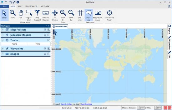
برنامج الخرائط البحرية | ReefMaster 2.0.40.0

يمكنك إنشاء خرائطك خاصة بك

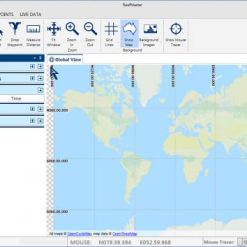
وعرض تسجيلات السونار ، وإدارة نقاط الطريق ، وإنتاج صور فسيفساء مذهلة ذات دقة عالية. ReefMaster

يستخدم البيانات دقيقة لإنشاء خرائط ثلاثية الأبعاد تحت الماء

يكتشف عمق المياه الموجودة تحتك

و يقوم بتحديد موقعك في البحر و يقدم العديد من الخدمات المهمة.

و انشاء خرائط تصل إلى  400 كيلومتر مربع.

برنامج الخرائط البحرية | ReefMaster 2.0.40.0
حجم البرنامج : 66.2 MB

With ReefMaster you can create your own maps, view sonar recordings

manage waypoints, and produce stunning high-resolution sidescan mosaic images. ReefMaster is a Windows PC application that uses data from sonar log files to create 3D underwater maps

combined with a multi-channel sonar viewer and graphical waypoint management.

Features:

Underwater Mapping

The depth sounder on your boat can detect how deep the water underneath you is.

Your GPS knows where you are.

ReefMaster puts this depth and position data together to build a highly detailed underwater map.

Create contour maps from sonar log files and view them in 2D and 3D with a range of base-map options
Combine mapping data from a wide range of sources, including native Lowrance and Humminbird sonar logs, GPX files, NMEA 0183, ESRI Shapefiles and text files.

Create maps of the sea or lake bed hardness using the optional Bottom Composition add-on module.
Calculate water volumes using the optional Volumes and Areas add-on module.

Create, drag and drop waypoints in both the 2D and 3D map views.

View and export maps in a range of pre-defined palettes, or create your own colour scheme.
Adjustable contour intervals in metric or US units.
Create maps up to 400km² in size.

Create maps in real-time with NMEA 0183 data:

Log depth and position data via NMEA 0183.

Create maps in real time, with a split screen (live-track/map) display.

Receive GPS and depth from up to two separate NMEA sources, with adjustable latency.

Show the live boat position on any ReefMaster screen.

Save your maps in a range of formats, including:

Single click export for a range of Lowrance and Google Earth Preset Map Styles.

Generate stunning AT5 vector or shaded-relief maps for Lowrance and Simrad GPS units.

Create contour maps as track files for display on Humminbird devices.

Export full-colour contour maps in Google Earth’s KML format for display within Google Earth and mobile devices.

Save geo-referenced, high-resolution map images for use in documents and websites.

Save contour maps in ESRI Shapefile format and 3D bathymetry in ESRI grid format for use in other GIS applications.

Multi-channel Sonar Viewer

Compatible with Humminbird and Lowrance sonar log files.

Multi-channel, split-screen display with smooth playback up to 30x.

Adjustable brightness, contrast and colour palettes.

Create waypoints in the sonar viewer.

Measure distance and estimate object height or depth using shadow length.

Adjust track-point depths in the sonar viewer to correct bottom-lock errors.
Waypoint Management
View and edit waypoints, with drag and drop in 2D and 3D.

Import and export waypoints in a range of formats, including native Lowrance, Humminbird and GPX

with automatic duplicate elimination.

Support for multiple waypoint sets, with easy, graphical copying and moving of waypoints across sets.

Attach any number of notes and images to waypoints.

Track ManagementStore your past tracks in ReefMaster, with easy access via the Asset Library.

View tracks over world base-maps.

Crop, split and merge tracks, and save the results back to your GPS unit.

Adjust track-point depths for lake-level or tide variations.

Log data from NMEA data sources.

Export raw track data in a range of formats, including comma-separated text files for use in other GIS applications.

Whats New:
Updates: official site does not provide any info about changes in this version.

تحميل موفق للجميع

انتهى الموضوع

كلمات دلالية :

برنامج الخرائط البحرية,تحميل برنامج الخرائط البحرية , حمل برابط مباشر برنامج الخرائط البحرية, حمل برابط تورنت برنامج الخرائط البحرية, أفضل برنامج برنامج الخرائط البحرية, أحسن ببرنامج الخرائط البحرية, اسهل برنامج الخرائط البحرية

, ReefMaster, برنامج ReefMaster, تحميل برنامج ReefMaster, تفعيل برنامج ReefMaster, آخر إصدار من برنامج ReefMaster


اساله و اجوبه و بدايْل حول برنامج ReefMaster

برنامج ReefMaster هو برنامج حوسبي يستخدم لإنشاء وإدارة أحواض الشعاب المرجانية. يوفر البرنامج مجموعة واسعة من الميزات التي تساعد المستخدمين على إنشاء أحواض الشعاب المرجانية الناجحة، بما في ذلك:

محاكاة بيولوجيا الشعاب المرجانية
تخطيط أحواض الشعاب المرجانية
إدارة أحواض الشعاب المرجانية
تشخيص مشاكل أحواض الشعاب المرجانية

تشمل الميزات الرئيسية لبرنامج ReefMaster ما يلي:

محاكاة بيولوجيا الشعاب المرجانية: يوفر البرنامج محاكاة دقيقة لبيولوجيا الشعاب المرجانية، بما في ذلك نمو الشعاب المرجانية وتطورها واحتياجاتها الغذائية.
تخطيط أحواض الشعاب المرجانية: يوفر البرنامج أدوات لتخطيط أحواض الشعاب المرجانية، بما في ذلك تصميم الأحواض واختيار الأسماك والنباتات والشعاب المرجانية.
إدارة أحواض الشعاب المرجانية: يوفر البرنامج أدوات لمساعدة المستخدمين على إدارة أحواض الشعاب المرجانية، بما في ذلك تسجيل البيانات ومراقبة الظروف البيئية.

تشخيص مشاكل أحواض الشعاب المرجانية: يوفر البرنامج أدوات لمساعدة المستخدمين على تشخيص مشاكل أحواض الشعاب المرجانية، بما في ذلك تحديد أسباب مشاكل الشعاب المرجانية.

نعم، برنامج ReefMaster مناسب للمبتدئين. يوفر البرنامج أدوات وتوجيهات خطوة بخطوة تساعد المستخدمين على إنشاء وإدارة أحواض الشعاب المرجانية الناجحة.

هناك العديد من البدائل لبرنامج ReefMaster المتاحة. تشمل بعض البدائل الشائعة ما يلي:

BRS Aquatics AquariaSim
AquaCalculator
ReefTank Calculator

سيرفرات أخرى للتحميل

1fichier

Openload

filecloud

share-online.biz

zippyshare

uptobox

file-upload

Turbobit.net

rapidgator.net

يهمك أيضًا

Scroll to Top